
Science Snapshots: Heeeereeee's El Niño!
El Niño (Spanish for The Niño) is here! Back on June 8, 2023, the U.S. National Oceanic and Atmospheric Administration (NOAA) announced via climate.gov that El Niño was in full swing and ready to wreck up the place. But what the hell does that even mean?
First, the basics. The El Niño-Southern Oscillation (ENSO) is a recurring climate pattern of warm and cool phases of sea surface temperatures in the tropical Pacific. Like most of us, it shifts every two to seven years between warm and cold phases (El Niño and La Niña) with a neutral phase some time in between. This temperature change extends west across the Pacific from the coast of Peru towards Oceania. A temperature change of 1 to 3 degrees Celsius (2 to 5 degrees in Freedom Units) may not sound like much, but that's HUGE for the ocean and it affects weather worldwide. While there are many different periodic climate-scale pattern oscillations/shifts, quintessential eldest child ENSO is the most well-known because it is one of the strongest and most important climate phenomena on Earth.
ENSO is tracked using the Oceanic Niño Index (ONI), which is a three month rolling average of temperature change, or a monthly index of the same called the 3.4 index (three-four, not three point four, because gods forbid we abbrev anything in a way that makes sense). It can also be tracked using the Southern Oscillation Index (SOI), which is the difference in sea level pressure between Tahiti and Darwin, Australia. When El Niño is underway, air pressure is below normal in Tahiti and above normal in Darwin, and vice versa during La Niña. The effect of sea surface temperatures on air pressure helps us see how ENSO results in large scale weather pattern disturbances. Or, as one of my meteorology professors told us, weather happens because God doesn't like unequal heating and cooling (heating/cooling changes air pressure, which in turn changes weather).
The name El Niño comes from the South American fishermen who first recognized the phenomenon of warming sea surface temperatures now and then around Christmas, hence the term El Niño (the boy child). I guess this is a nice way of saying "Sweet Baby Jesus, this warm water is fucking with our ability to fish." Sir Gilbert Walker, an English physicist and statistician, discovered the SOI but did not link it to El Niño noted in South America. This link occurred in the late 1960s, when Jacob Bjerknes, a Swedish meteorologist, and others made this connection and coined it ENSO. Because if you work in the realm of atmospheric science, you know the Norwegians, Swedes, and Finns are the best of us and if a dude discovered an important weather principle sometime before 1980, it came from Scandinavia (Ted Fujita being a notable exception).
But Captain, why should I care? Because unlike normal forecasting, which is accurate at most about 5 days in advance, maybe 7 if we're really on top of our games, the ENSO phase allows us to make seasonal predictions about how generally the climate may be a few months later for many areas around the globe. This is termed teleconnections. A teleconnection is a significant relationship between weather phenomena at very far apart locations across the earth. For example, warm sea surface temperatures off the coast of Peru resulting in an abnormally dry winter-spring period in eastern Australia. Remember: climate is what you expect, weather is what you get.
Here is a list of teleconnections for various areas of the world for El Niño in December to February. Feel free to ping me if your area isn't represented here and you'd like to know more (it could be you don't have any, like where I live). Amaze your friends with your psychic predictions! You just KNOW it's going to be wetter than normal this winter in Texas. YOU. JUST. KNOW.
El Niño Dec-Feb teleconnections:
North America: Wet across the southern US and far northern Mexico. Drier than normal in the eastern midwest of the US from about Missouri over towards the western Appalachias. Warmer than normal in Alaska and the western 2/3 of Canada. Cooler than normal across the southern US and far northern Mexico.
South America: Dry across northern Brazil and Guyana, Suriname, and French Guiana. Wet and warm on the western shore of the continent (Peru, Ecuador). Warm in southern Brazil, wet in northeastern Argentina, Paraguay, and Uruguay.
Africa: Wet in and around Kenya, dry and warm in far southeastern Africa across to Madagascar.
Asia: Warm in Japan and across India and southeastern Asia. Dry and warm in western Indonesia, Malaysia. Dry across northern and southern Oceania. Wet and warm in central Oceania and further east towards Peru.
Australia: Dry across extreme northern Australia, warm in southern Australia (southern NSW and Victoria). Note that during the winter (Jun-Aug), Australia REALLY dries out. Depending on how long this El Niño lasts, Australia may be at risk of bushfires due to prolonged dry periods.
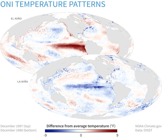 |
| Example ocean sea surface temperature anomalies (differences from normal/expected values) for El Niño (top) and La Niña (bottom). We're currently experiencing warming off the coast of Peru, an El Niño. |
Read more about ENSO here: https://www.climate.gov/enso
More information about Australian ENSO impacts here: http://www.bom.gov.au/climate/updates/articles/a008-el-nino-and-australia.shtml
More information about teleconnections with a focus on North America here: https://www.weather.gov/fwd/teleconnections
More about Argentina's ENSO teleconnections here (en español): https://www.smn.gob.ar/enos


Comments
Post a Comment